Printable version (without photo links)
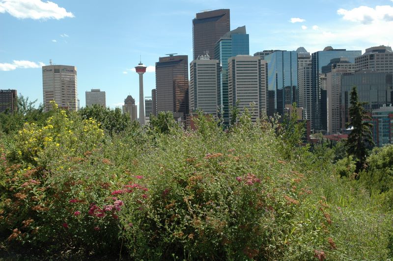
My flight arrived in Calgary on time or even a bit early (~12:15 PM). I quickly got my luggage, cleared customs, and went to wait for my rental car. If I had not had Avis Preferred service, I might have still been waiting for the car when Mom arrived; as it was, I was out of the airport by 1:15 or so - not bad at all. I went to a nearby Safeway (thanks to Google Maps) and picked up water and snacks, drove around a bit, finding some nice views overlooking downtown Calgary and the Bow River. I went to 4:30 Mass at Our Lady of Grace Italian Catholic Church, about 15 minutes from the airport and 3 blocks from the Holiday Inn where we would be staying the last night of the trip! I couldnĺt reach Mom on her cell phone after Mass, so I went back to the airport, and found her on my second circuit (on the third I wouldĺve parked and looked for her). So, the most difficult part of the trip - getting together - was done.
We stopped at a Dennyĺs on the way out of Calgary, across from the Winter Olympics facilities along Highway 1. I found the choice of ôCanadian cheeseö for my (veggie) cheeseburger very interesting - until I realized that it was going to be American cheese under a more appropriate name! Sure enough, thatĺs what Canadian cheese is.
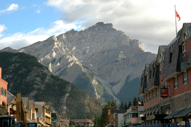
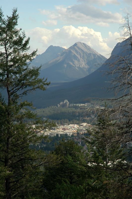
We got to Banff at 8PM or so - still daylight! The earliest sunset during our trip was about 9:30PM - but of course the mountains blocked the sun earlier than that. We were very pleased with our hotel and settled in for the night.
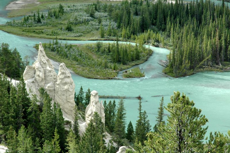
We started our day early, as was appropriate when we were used to getting up an hour or two earlier. Not many people were out when we started walking around downtown Banff about 7AM, but we did find good coffee and rolls at a local place, Evelyn's Coffee Shop. Our first sightseeing (other than Banff itself) was a drive up Tunnel Mountain. Our first stop was at the Hoodoos interpretive trail, over the Bow River, where we both walked the short trail and looked at the views. There are only a few hoodoos here, unlike the hundreds or thousands at Bryce Canyon, but they are suitably named - the same sort of weird stone outcroppings.
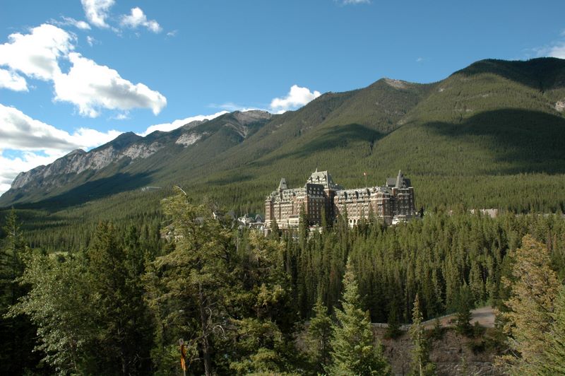
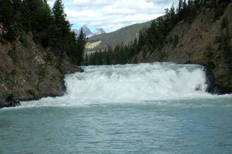
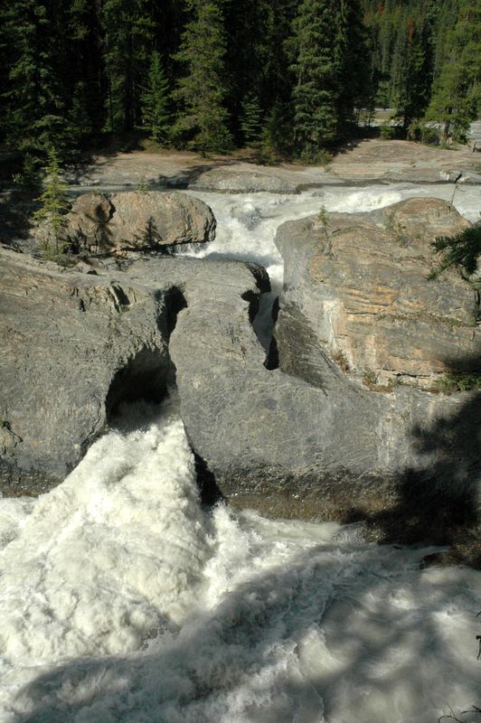
Driving on down Tunnel Mountain Drive, we got to a busy turn - ôSurprise Cornerö. Many people were crossing the road to an observation deck where you could see the Bow River, Bow Falls, and particularly the Banff Springs Hotel - an absolutely huge Banff landmark. If you walked along the road you could get a better view of Bow Falls and the rapids/cascades before and after it.
Continuing on our morningĺs driving tour, we crossed the Bow River and drove up Sulphur Mountain past the hot springs to the gondola. That turned out to be as close as we got to any of the activities there. We then passed the Banff Springs Hotel and took the scenic drive through the Bow Springs Golf Course. Part of the route goes well past the golf course itself and becomes very peaceful and scenic along the river(s) (the Spray River and the Bow River converge just above Bow Falls). The route back took us past the parking lot for Bow Falls, so we stopped there and I walked a little upstream to get a better view (stopping before I had to go DOWN again).
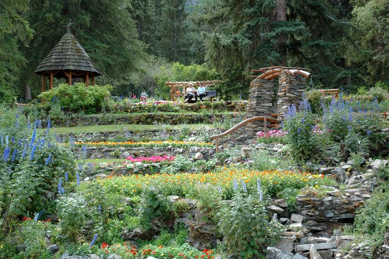
We decided weĺd had enough views for the morning, so we stopped at Philĺs family restaurant for pancakes for lunch. This was a good choice, since afterwards we just crossed the street to Canada Place to see Cascade Gardens. These beautiful gardens were built as part of a depression relief project in the 1930s.
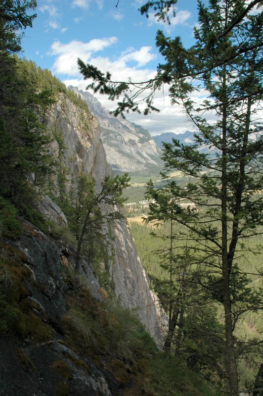
One of my goals NOT shared by Mom was to do some hiking most days. Tunnel Mountain was described as a mountain that any ôreasonably fitö person could climb in the Rockies, with an elevation gain of 300 meters/975 ft. Leaving Mom at the hotel, I headed out - and promptly wondered about my fitness level as the climb seemed really strenuous right away! The first part was the steepest, plus I guess being at 4000/5000 feet made a difference. I felt better when I was almost back to the bottom and I encountered what seemed to be mother, son, and grandmother coming up. The mother (probably younger than me) was very red in the face and asked me, ôAre we almost to the top?ö I had to tell her noůbut I did reassure her it would get easier. The views from the top were worth it.
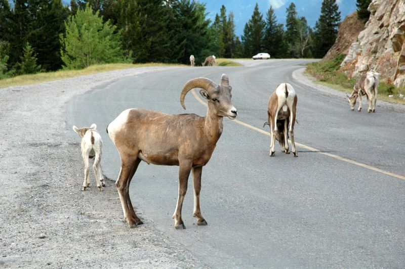
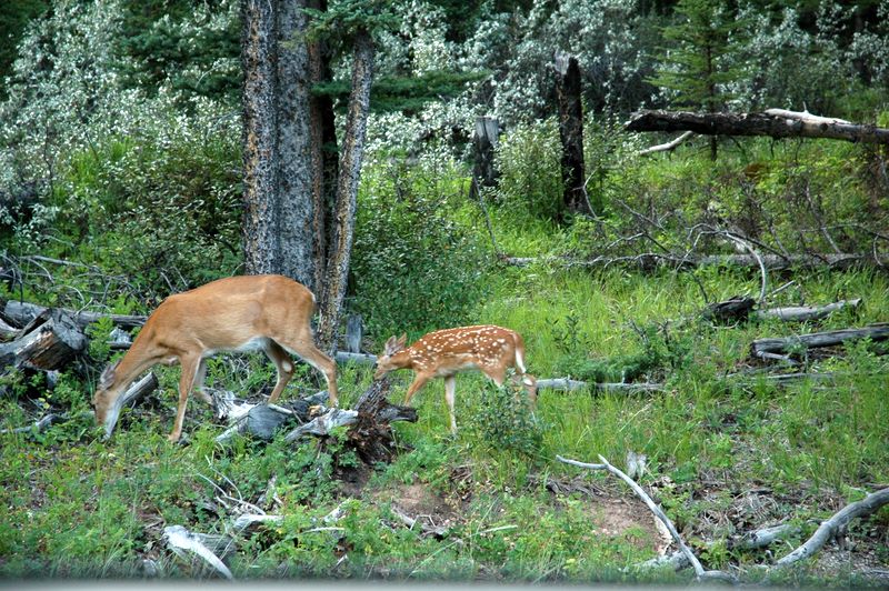
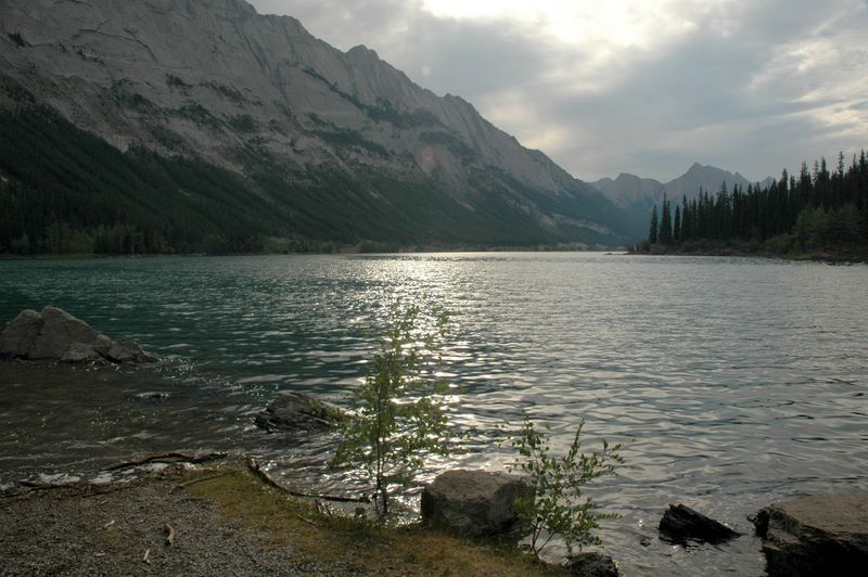
Getting back to Mom after a couple of hours or so, we relaxed for a while, then went in search of an early dinner. The most promising restaurant from my perspective had too long a wait at 6PM and told us to try earlier (!!) so we wound up with pizza slices at the food court at the (very small) Cascade Mall. That left us plenty of time after dinner to drive out to the scenic Minnewanka Loop, where there are several pretty lakes, nice mountain views, and wildlife. We were within a few feet of bighorn sheep (who were busy licking minerals from the ground and didnĺt care about us), plus we saw elk, ground squirrels, and a doe with two fawns. We were probably lucky we didnĺt see the grizzly which had a bad ôinteractionö with some humans that same day (they accidentally got between the mother and cubs).
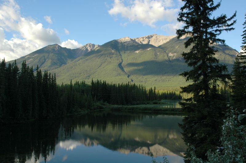
We still had daylight and (some) energy, so we drove over to the Vermilion Lakes. The three lakes are very pretty, and a nice place for bicyclists. I made one bad choice: we stopped at the Fenland Trail on our way back, about an hour before sunset. Really bad to walk out into a wetland near dusk, especially in a climate where the mosquitoes have a short season to work in! We quickly abandoned the trail and headed back to the car, repellent or no.
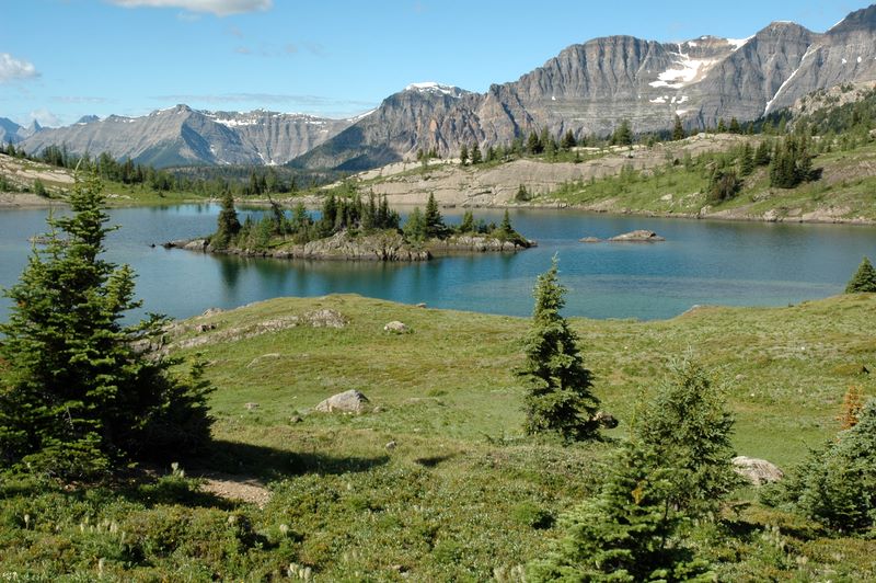
This was one of the few pre-planned days of the trip. After a light breakfast in the room (coffee, cereal, and banana - like home!) we drove up to Sunshine Village, a huge ski area (some 170 ski runs). In the summer they have shuttle buses instead of ski lifts up to the lodge area, where you can hike around the alpine meadows by yourself or with a guide. I had signed up for a guided Sunshine Vistas walk. I was surprised to learn there were only three of us: Yvette, our guide, from Quebec; Malvika, a young software engineer originally from Bangalore, and me. The three of us had a great time. The first part of the hike took us to beautiful Rock Isle Lake. We couldĺve probably spent the rest of the day enjoying the view there, in the midst of subalpine flowers and clumps of trees. Instead, we went on into forest around Larix and Grizzly Lakes, stopping to enjoy the Simpson Valley Viewpoint in between. One interesting feature of this part of the walk is that we were in bear country AND couldnĺt see far ahead of us (since we had descended into forest). So, we couldnĺt just quietly walk along and enjoy the silence; if we werenĺt talking, Yvette had us start clapping. You donĺt want to surprise a bear!
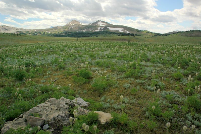
After making the loop around the lakes, we decided there wasnĺt enough time for us to make the climb to the Standish Viewpoint (another kilometer and a pretty good climb) without rushing too much to get back by 2PM, which we all needed to do. Having just had a discussion about being ôgoal orientedö versus ôenjoying the journey,ö it seemed appropriate that we didnĺt overdo it in order to pack in one more destinationConsidering we were hiking at ~7200 feet on my second day in the mountains, it wouldĺve been difficult for me anyway. We did take a side trip on the trail toward Mt. Assiniboine on the way back, into an area of huge meadows - quite different from the other environments weĺd been in. Total distance was 5-6 miles.
Unfortunately, I found that Mom had mostly stayed in the dark ski lodge building in my absence - she didnĺt have sunscreen on, and she found sheĺd brought too much ôstuffö with her to feel like walking around a lot. (The initial climb up from where the bus left us was quite steep anyway.) After hiking for some 4.5 hours, I was ready for a break. When we got back to town, we went for a late lunch/early dinner by open windows (no screens) at the Old Spaghetti Factory in Cascade Mall. Then we drove up Mt. Norquay Rd to see the views there (and encountered some intrepid skateboarders who were skating DOWN the road!). After relaxing for a while, we spent the rest of the evening walking down Banff Ave. along with everyone else, and browsed the art and jewelry. We discovered ammolite, a gemstone found only in this part of Canada in fossil ammonites (sea snails). It has the rainbow effect of mother-of-pearl and is very beautiful (and expensive).
We checked out of our nice hotel in Banff to move on toward Lake Louise via the scenic Bow Valley Parkway. This route is noted for lower speed limits than the Trans Canada Highway and more wildlife; in the spring it is closed for the evening and early morning hours to protect the wildlife.
We got off to a good start after stopping to see (and photograph) the lake at Muleshoe (about the first place you can stop on the parkway). When we pulled out of the parking lot, there were cars everywhere - clearly a wildlife jam. The cause was rapidly apparent - an elk with the biggest rack of antlers Iĺve ever seen. He apparently stayed around that spot grazing for quite a while, despite a large audience - another photographer whom I talked with later in the day had probably come by at least a half hour later than us, and the elk was still there.
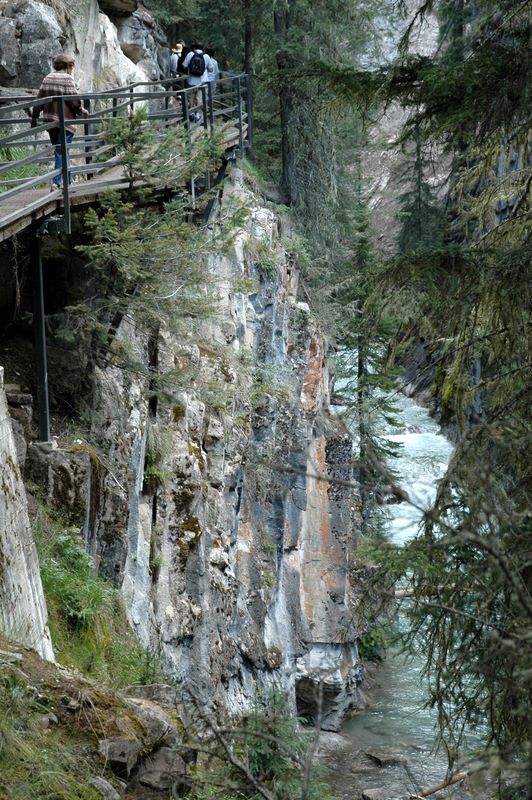
We made some stops for scenic mountain views, but my next goal was to get to Johnston Canyon before it got too crowded. The walk to the Lower Falls (l mile round trip) is very, very popular; many people go on (like I did) to the Upper Falls (an extra 2 miles) or even further to the Ink Pots. It was a beautiful place, and we did beat a lot of the crowds - by the time I got back from the Upper Falls, cars had overflowed the parking lot and were parked on the roadside. Mom had time to take a leisurely walk to the Lower Falls and back, plus get coffee at the nearby coffee shop/restaurant before I returned.
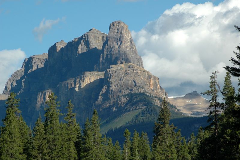
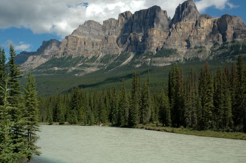
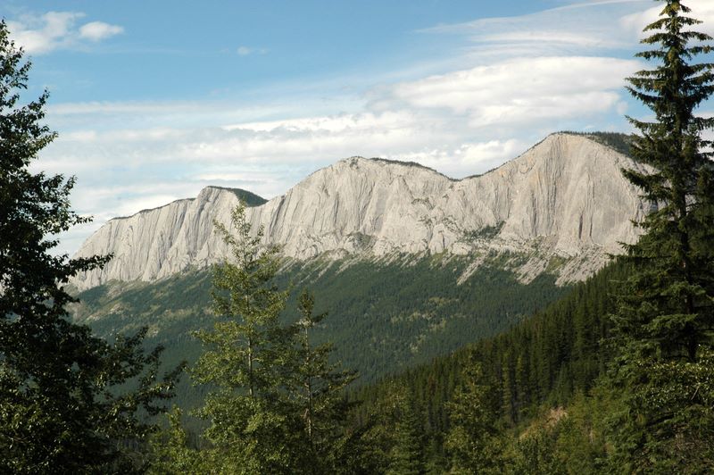
The next major ôviewö was Castle Mountain. This multi-peaked mountain dominates the view for quite a distance! There was an attempt to rename it Mt. Eisenhower after World War II, but it didnĺt ôtakeö; one of the peaks is now called Eisenhower Peak.
Before too much longer, we arrived at Lake Louise. As we took the road from the village of Lake Louise to the actual lake, the traffic made me realize that weĺd better see if we could walk from our hotel! Fortunately, Deer Lodge is the closest hotel to the lake after Chateau Lake Louise, for a fraction of the priceůand our room was even ready when we got there (which was a BIG help). The fact that our room wasnĺt much bigger than absolutely necessary for the furnishings didnĺt much matter. We walked the short distance to the Chateau well before our 3:00 reservation for tea in the Lakeview room (the other event we had pre-scheduled for the week, after Sunshine Meadows). I was glad that Iĺd mentioned I was a vegetarian when I made the reservation, as it DID matter. Our menu consisted of sparkling wine, finely cut fruit salad with a liqueur topping (I think), finger sandwiches - cucumber, egg salad, salmon, chicken curry wrap (I had two each of the vegetarian ones), scones with Devonshire clotted cream and jam, and mini pastries: lemon meringue pie, eclairs, chocolate bombe, mocha fudgy square. And, of course, our choice of teas! We each got a small box of Chateau Lake Louiseĺs own tea blend as a souvenir of our (expensive) afternoonĺs treat. My photos include our view from our window seat and a picture of the harpist who was playing while we ate.
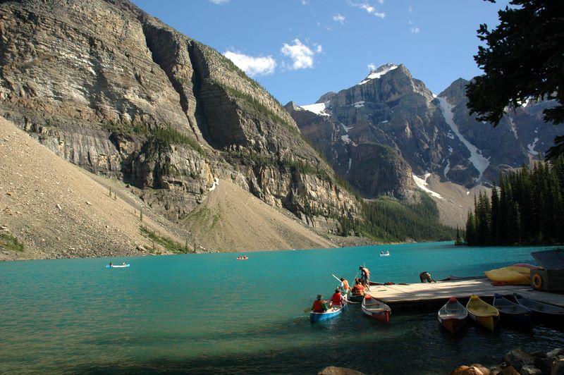
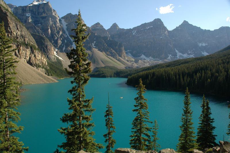
After tea, we walked around the garden between Chateau Lake Louise and the lake for a little while, then Mom went back to the hotel and I walked partway down the Lake Louise lakeshore trail. While I was walking, Mom ran into Malvika, the woman I had hiked with the day before, and her mother! When I got back, we headed off to Moraine Lake, a wilder and some say more beautiful neighbor of Lake Louise. Both are fed by glaciers. I took the lakeshore trail at Moraine Lake to the far end. While walking, I ran into Malvika, and stopped to visit with a couple from New Zealand (the husband noticed I had a similar Nikon - a good conversation starter). I got back to find Mom had just gone out to look for the car after walking partway down the lakeshore herself. Before we left, I climbed up to the viewpoint for the famous ôten peaksö (formerly on Canadian currency) by the huge rockpile at the foot of the lake.
Before going back to the hotel for the last of the evening, we checked out Lake Louise Village. There really isnĺt much to see; a couple of gas stations, various necessary services, and the Samson Mall, which is a strip mall with pretty much all the retail available: a small grocery store (more of a convenience store), a couple of souvenir shops, a bakery, a family restaurant, and of course a sporting goods store. I went in there to see what might be interesting. After a couple of serious hikes and anticipating others, I was wondering if a walking stick or something similar would be wise. After spending some 20 minutes with a nice young German fellow who explained how to use them, I bought a pair of very good trekking poles, rationalizing that the cost was less than what any followup to an injury would be. I had some confidence, thanks to Rolandĺs instructions, that the poles WOULD help protect my knees and ankles, as well as providing stability in steep or rough areas.
At the hotel, I decided to try one more amenity: their rooftop hot tub. It had a great view of the mountains! It was a fine place to end the day.
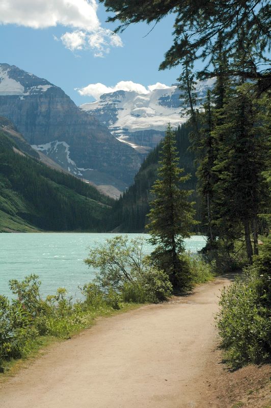
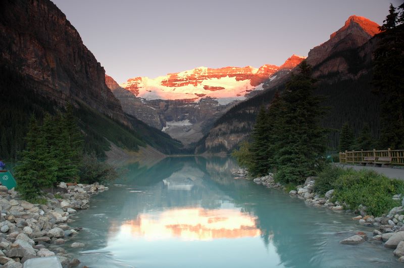
This was the one morning I was sure I wanted to get out and ready to take pictures before sunrise. At 5:30AM, I was the first photographer out at the lakeshore (but hardly the last). I enjoyed watching the mountains light upůand I enjoyed getting photos of it. By 7AM I was back at the hotel, where we had a good breakfast. On the way out of town, we stopped at Laggan's Bakery (highly recommended in my guidebook) for goodies for later in the day. I got an Eccles Cake (a puff pastry filled with currants and raisins) which I really enjoyed.
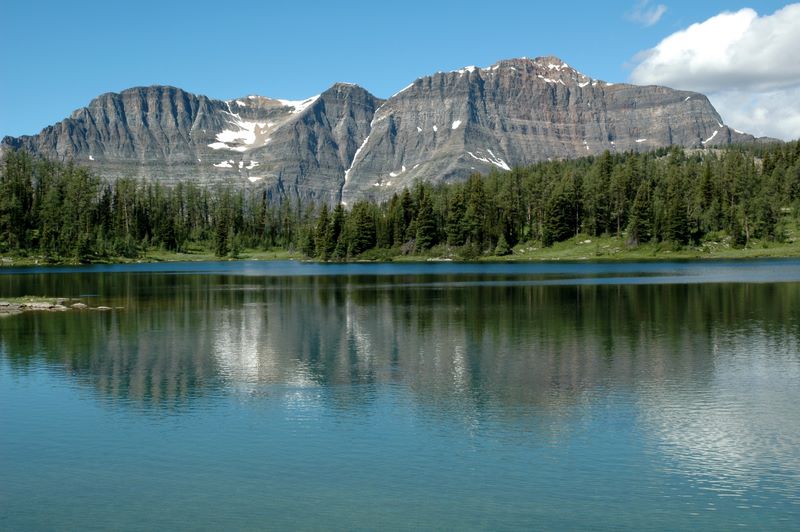
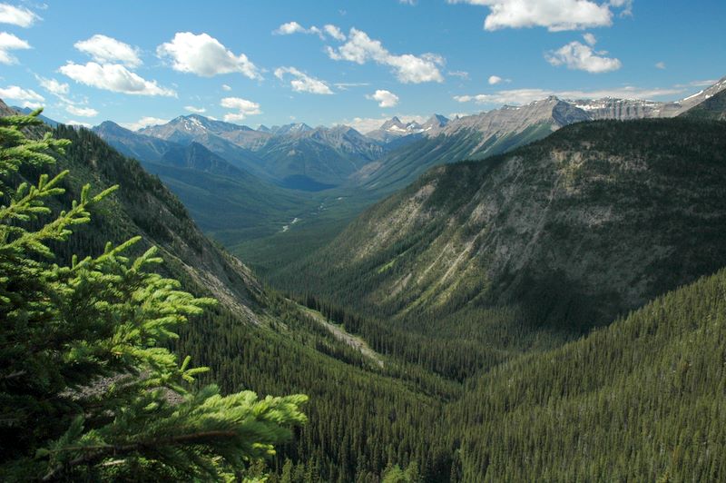
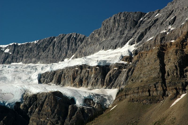
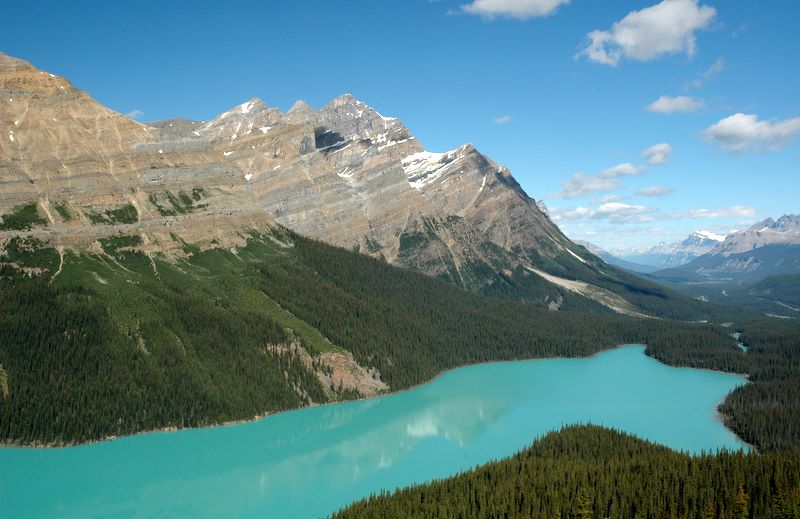
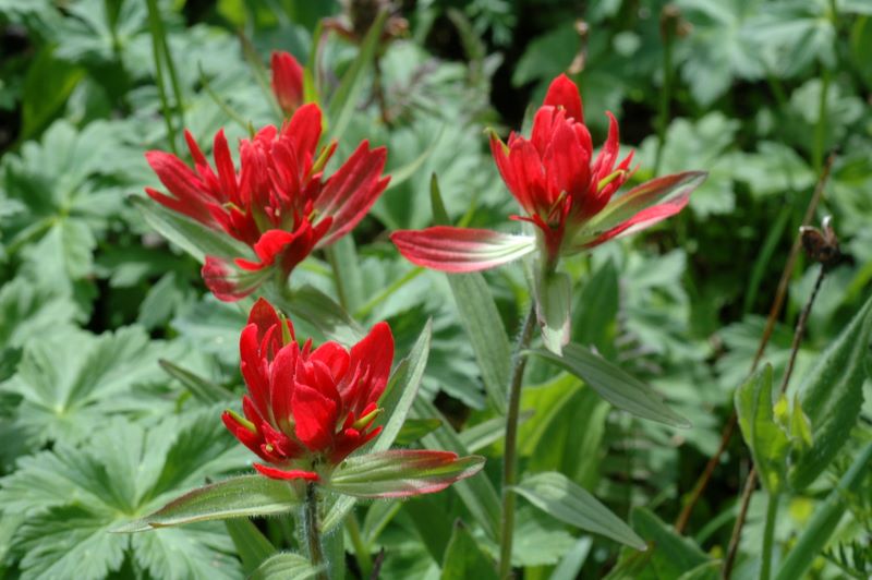
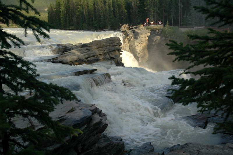
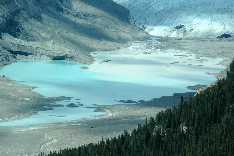
We then headed up the Icefields Parkway (one of the most scenic highways in the world) toward Jasper. Our first stop was photogenic Lake Herbert. Soon we were in the midst of glaciers; one of the first really big ones was Crowfoot Glacier (which used to have three ôtoesö but now only has two). Many glaciers have beautiful turquoise lakes in the valleys below, since the suspended minerals from the ice melt change the color of the water. We stopped to see big Bow Lake, then took a walk to the viewpoint at Bow Summit, the highest point in the road system in Banff National Park. I thought this was going to be an easy walk for Mom, since it was handicapped accessible; I completely missed the fact that the handicap parking was WAY up the hill from the regular parking. The walkie-talkies Iĺd brought came in very handy, as I could radio Mom and encourage her to keep going, because the view of Peyto Lake, Peyto Glacier and the surrounding mountains was great! I decided that was a long enough walk for me too at that point, and skipped any further hiking.
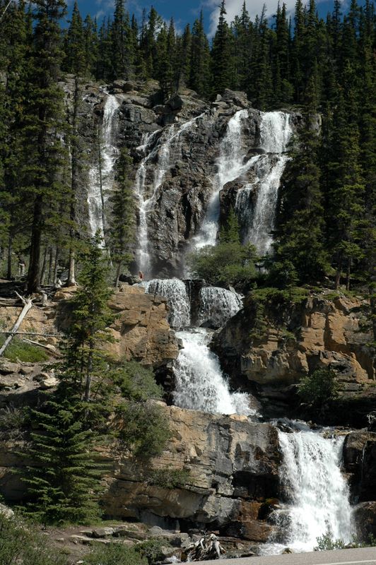
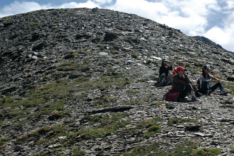
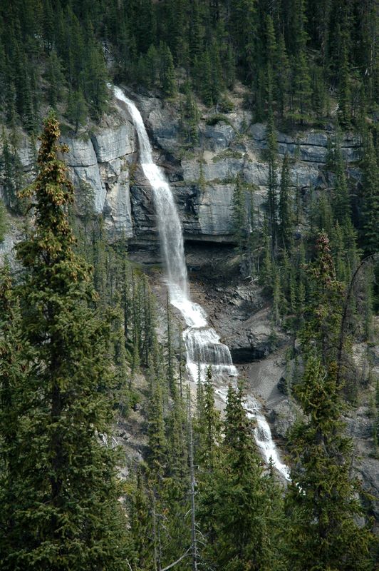
My plan was to hike the Parker Ridge trail, ôthe best short hike" in the park, and use my trekking poles (since itĺs short but steep). I was tired and the parking lot was packed, so I decided it would be better for the return trip. We also skipped the Icefield Centre and the Ice Explorers tour for the day - it was early afternoon and the place was a sea of buses, cars, and people. We did stop to enjoy the Weeping Wall, where there are several waterfalls on one mountainside. We also really liked Tangle Creek Falls, which was right beside the highway.
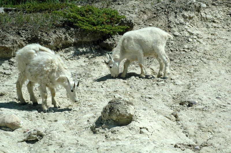
Probably the highlight of our first afternoon in Jasper National Park was the mountain goats we saw at a mineral lick along the road. We got the impression they were probably common thereůbut we passed the same way three more times and didnĺt see them again. Mountain goats are less common than bighorn sheep, so we were glad to have seen them.
When we got close to Jasper, we took the 93A back road (where the turnover is for Athabasca Falls - again, we skipped that for the time being). 93A was a nice scenic route but truthfully weĺd had enough scenery driving up the Icefields Parkway by that time. Reaching the Athabasca Hotel in downtown Jasper, we found that our room was even smaller than at Deer Lodge. We already knew we were saving $70/night by sharing a bathroom down the hall; we were a little surprised to find out that there was one stall each for men and women on each FLOOR! (It wasnĺt much of a problem on the two weeknights we were there, but Friday night got a bit busierů)
After napping for a while, we walked around downtown (VERY convenient to our hotel). We got a pizza at North Face Pizza, across the street from the train station and a steam locomotive (which I didnĺt get back to photograph for John). Mom was feeling a bit under the weather when we got back, so I decided it was time to do laundry. (I only brought enough clothes for half the trip so laundry was a mustů) A quiet evening after a very long day was most welcome.
We started our day by waiting for the Soft Rock Cafe to open (apparently most people arenĺt out before 7:30AM). Their cinnamon rolls were the draw - they were certainly big! We then headed to Mt. Edith Cavell. I had two hikes in mind: one, the Path of the Moraine Trail, was just one mile and sounded fine for both Mom and me. As often seems to be the case, there was a bit more to that one mile than the description suggested! It was well worth the effort, including the initial climb up a glacial moraine (though Mom might have opted for NOT doing the loop and just walking up the bottom of the valley, if she had known). Standing on the shore of a lake full of chunks of ice was very interesting.
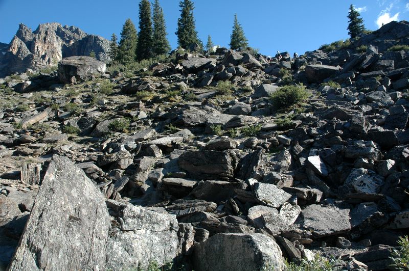
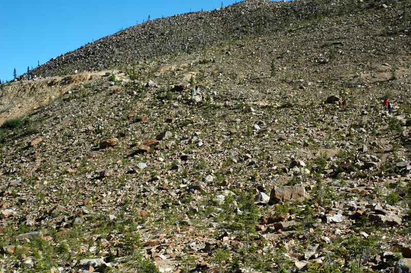
After we got back from that, I set out on my own for Cavell Meadows. This was a hike primarily to see alpine wildflowers and get above the tree line. I didnĺt realize that the longer loop (5 miles) plus the ascent to the summit (not part of the loop) would go up to where there wasnĺt much of ANYTHING growing - just loose scree. I didnĺt quite get to the top, but I got plenty far enough for me. My trekking poles were VERY handy, especially in narrow spots on the loose rock and on the steeper leg of the loop on the way down. I didnĺt have nearly as much knee trouble afterwards as I think I would have otherwise.
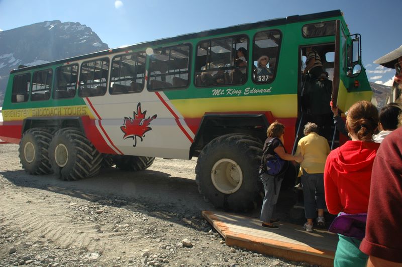
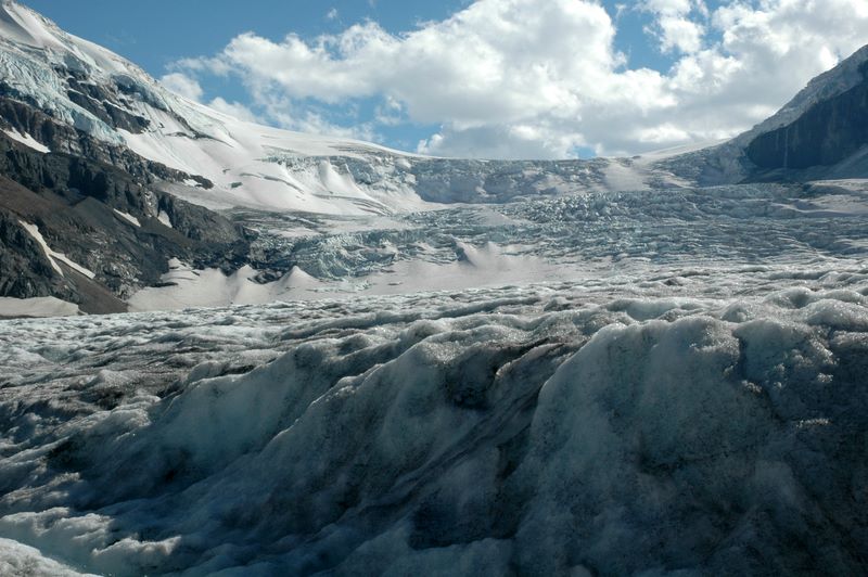
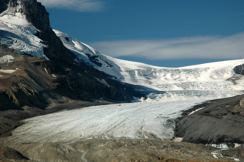
When I got back, Mom was all rested up and ready for the next adventure. We went back down the Icefields Parkway to the Icefield Centre and took the Ice Explorer tour about 5PM, after the tour buses had gone. It was very interesting to get out on a glacier and see how big it really is. It was hard to believe that we were standing on ice 1000 feet thick! There are some 23 Ice Explorer vehicles, 22 of which are operated by the Brewster tour company (which seems to operate most everything in the Canadian Rockies) and one which is U.S. hands in Antarctica. Even the start of the ride was interesting, as the Ice Explorers go down a 36% grade to get to the glacier!
Going back to Jasper, we decided to see if this was a good time to visit Athabasca Falls (which I had been told was a ômust seeö). It was a good time, and it definitely was something to see! It was especially beautiful in the late afternoon light. (Even though it was 7:30-8:00PM when we were there, it was well before sunset, which was close to 10PM in Jasper.) We finished our day with a Greek dinner at the L&M Family Restaurant, recommended by the shuttle bus driver at the Icefield Centre.
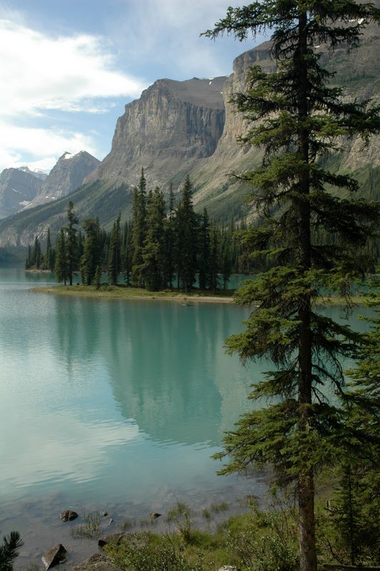
We decided that ôclose byö and ôopen earlyö were both good, and had breakfast at Smitty's Family Restaurant, across from the hotel. We wanted a reasonably early start to get to Maligne Lake in time for the first (10AM) cruise to Spirit Island. It is less crowded early in the day, and the lake is calmer; we also found that it was a big plus to be there before it got hot. The lake and Spirit Island were beautiful. Afterwards we had a very good lunch at the View Restaurant on the lakeshore. They had excellent vegetarian chili, and Mom liked their beef stew.
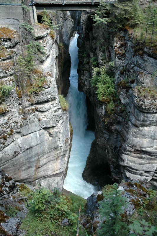
Our other ômust seeö in Jasper was right up the road at Maligne Canyon. There are six bridges across the canyon; most people start at the most scenic part (the 1st and 2nd bridges) while only the serious hikers go to the 5th or 6th bridges. I split the difference and spent about an hour there, going from the 2nd bridge down to the 4th and then back to the top. Mom walked up from the 2nd to the 1st bridge, so she got to see the best parts. It was quite hot and sunny by then; I would like to go again when the light was different for photography, but it was still enjoyable.
We spent the rest of the afternoon driving through the eastern part of Jasper, along Rt. 16. We took the Miette Hot Springs side road, but didnĺt actually get closer to the springs than the parking lot (you could smell the sulfur from there). It was way too hot for hot springs to be appealing. Punchbowl Falls is also along the Miette Hot Springs road, but the guidebook author who called it ôphotogenicö has different ideas than I do. En route back, we stopped where a flock of bighorn sheep had been since we were headed east, and watched them until the leader decided it was time for them to cross the highway. It was clear why they have frequent warning signs about wildlife on the road!
We ate dinner at another Greek restaurant, ôSomething Else.ö Even the Italian-sounding restaurants in Jasper seemed to be Greek! It was OK but the service wasnĺt very good. I went for a walk later and found us a nice fruit and custard tart to share for dessert - much more satisfactory than dessert would have been when we were getting annoyed at the restaurant.
We decided that breakfast at Smitty's would work again before setting out on the Icefields Parkway for our return trip. We stopped at various overlooks we'd skipped before, including a great high panoramic view just north of the Icefield Centre, and Bridal Veil Falls (back in Banff National Park). The light was nice for different pictures this time, which worked for me. We also stopped at the Icefield Centre again, just to stretch our legs. The view of the glacier we had visited was still very impressive.
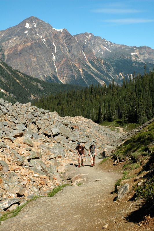
Once we crossed back into Banff National Park, we quickly arrived at Parker Ridge, where I wanted to go hiking. It turned out that the ~3 mile hike was steep (as advertised) but NOT as difficult as the Cavell Meadows trail Iĺd taken a couple of days earlier, so that was nice. The view of Saskatchewan Glacier was well worth the climb, and it was fun to see more alpine plants. I got back in less time than planned (for the first time) so that was a bonus.
When we got to the end of the Icefields Parkway, we headed west into British Columbia and Yoho National Park. The first overlook there is of the ôSpiral Tunnels.ö When the Canadian Pacific Railroad built its line through Kicking Horse Pass (where we were), they were saving distance at the expense of a VERY steep grade, which required extra engines to go up and a great risk of runaway trains going down. Eventually they built two spiral tunnels (one through a mountain on each side of the valley, if I understood correctly) to reduce the grade. We got lucky and arrived at the viewpoint when a train was entering the spiral tunnel that was visible there, and we saw it come out and cross over itself! (The freight trains are VERY VERY long thereůand when they go through they block access to the tiny town of Field, which is the only community in Yoho.)
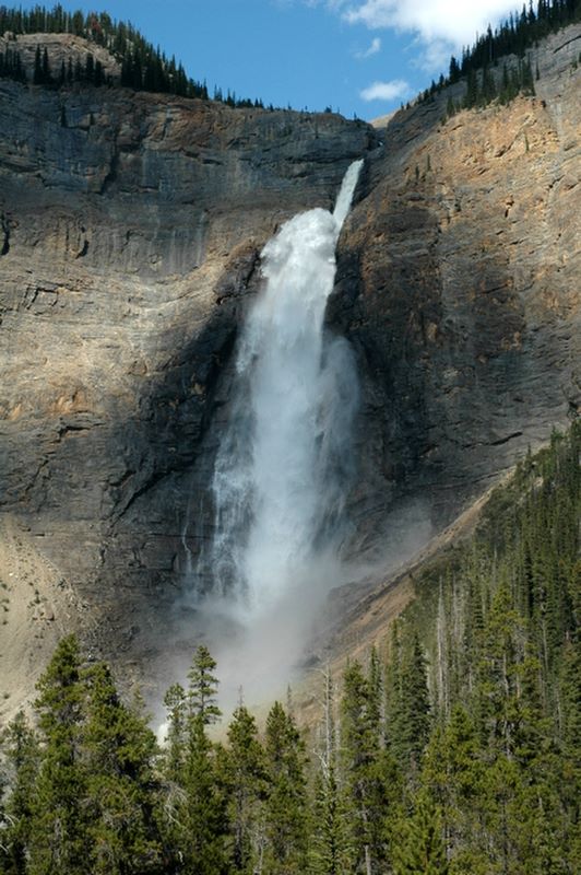
After leaving the Spiral Tunnels overlook, we went to Yoho Valley road and drove to Takakkaw Falls. Takakkaw is an Indian word meaning ômagnificentö - and it was well named. Takakkaw is one of the highest waterfalls in Canada, and the water just shoots off the side of the mountain. The road to get to it is also impressive, especially the back-to-back switchbacks which require larger vehicles like RVs to back up to round the corner.
Before going to our hotel at Emerald Lake, we ate dinner at the Truffle Pigs CafÚ in Field. This is a very unusual little place, the closest thing to a grocery store that Field has (and it isnĺt very close) with fairly limited seating indoors and out, but food that is anything but routine. We both had excellent salads and some of the best bread Iĺve ever had.
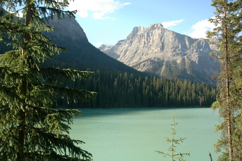
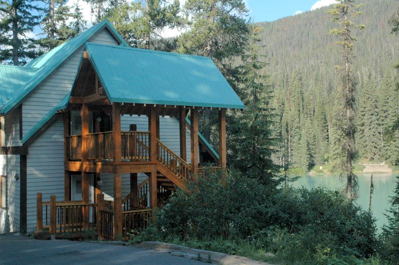
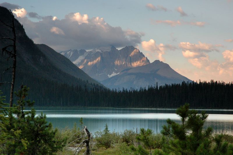
Finally we headed to Emerald Lake Lodge. Overnight guest parking is a little distance from the lakeshore - a shuttle bus runs 24x7 as needed to ferry guests and luggage back and forth. Soon enough we were in our room right on the lakeshore, one of four in our chalet. The hotel itself is on a peninsula, separated from the mainland by the Emerald River and a lagoon. The setting was absolutely amazing, and we were relieved to find that despite the upscale setting and price, dress was absolutely casual (as we were).
I intended to get up early on Sunday to watch the sunrise from the other end of the lake, but gave up on that idea when the alarm went off. (The birds got up far earlier than we did! It was quite loud outdoors.) Instead, we started out with a good breakfast in the main dining room of the lodge. It turned out to be the sort of day to just relax and take the occasional stroll around the immediate area - perfect when you have your own balcony and a great view to enjoy! We ate takeout sandwiches from the restaurant just downhill from us toward the bridge for lunch.
I decided a trip to an actual store, in Golden (35 miles away), was needed. The extra couple hours of driving (through exciting mountain roads and some amazing road construction, including a VERY high bridge) was compensated by our realizing that we did NOT want to take the same route the next day, as I had planned. So that was a good lesson to learn. We got back to Field just in time for Mass at 5PM. When Mass started, Mom and I were 25% of the congregation! Attendance increased to 11 before we got through. (With the aforementioned freight trains blocking off Field on a regular basis, people had built-in excuses for being late.) They only have Mass in Field during July and August, and everyone was visiting (the priest introduced us to each other by our home locations, which was nice). I guess any local Catholics go down to Golden to be part of the regular community there.
On the way back to the hotel, we stopped at the Natural Bridge. Once again, it was much nicer to visit later in the day, when most of the crowds were gone. We had dinner at Cilantro's by the Lake (a short distance from our chalet). I felt more energetic afterwards and took a photo walk as the sun was going down.
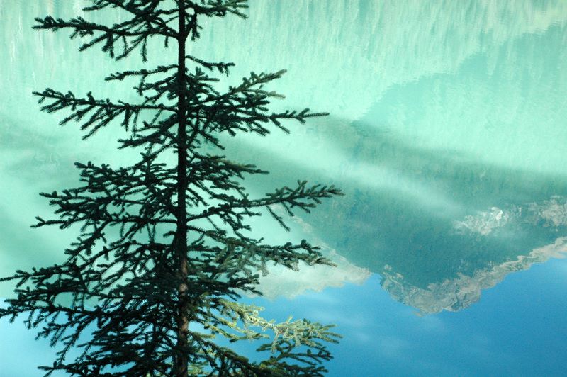
I still didnĺt get up in time for sunrise (and didnĺt seriously plan to); however, I did set out about 6:35 to walk around Emerald Lake (~3 miles) and take pictures. I thought Iĺd be back about 8:00; it was a good thing I had the walkie-talkies so I could tell Mom Iĺd be a while yet! (I finally got back at 9:15 or so.) I nearly lost my walkie-talkie; fortunately, it started raining and I realized Iĺd dropped it when I was putting things in my backpack, and it wasnĺt too far back to where Iĺd lost it. (The rain didnĺt last, which was a good thing too.) We had another great breakfast (maple cream-filled pancakes and fresh fruit) in the main dining room, then I had to get ready to leave before checkout at 11 (which I managed with plenty of room to spare).
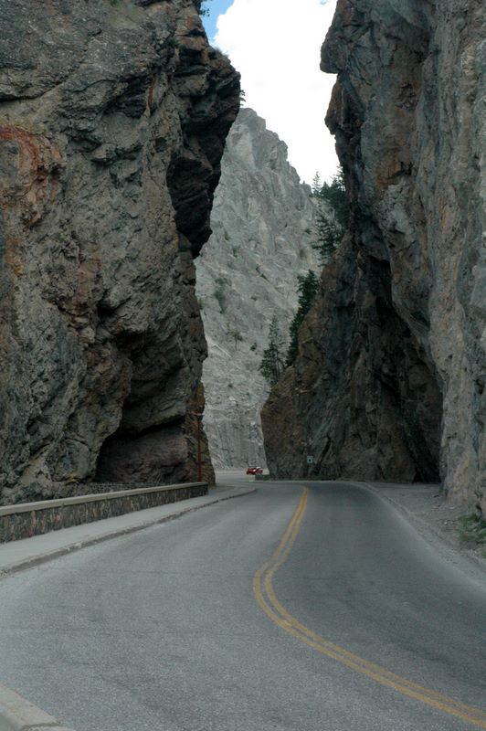
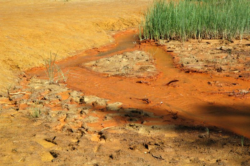
We headed back east on the Trans-Canada Highway and back to Castle Junction, where we took Rt. 93 southwest through Kootenay National Park. This only took a couple of hours, and we stopped for lunch at Back Country Jack's Museum Restaurant in Radium Hot Springs. We took our time with lunch so I could have slightly better photo light going east. Places we stopped going back included the impressive ôentranceö through a narrow pass above Radium Hot Springs, the aptly named Redwall Fault (yes, itĺs very red), Olive Lake - a nice peaceful place with a short boardwalk and spring-fed, crystal clear water, Kootenay Valley Viewpoint where you could see for miles and miles, Hector Gorge, and Numa Falls. The only place I took more than a brief walk was at the Paint Pots (a 1.2 mile round trip). This is a place where the Indians used to come to get red and yellow pigment, and ochre used to be mined here. I also wanted to visit nearby Marble Canyon, but it was closed; one of my books suggested it had been closed since widespread fires several years ago. There was a large section of dead trees in the northeastern part of the park.
Our last stop in the Canadian Rockies was back in Banff, where we stopped for a break and souvenir shopping. Mom got a cap for Jack, and I got Dave a wooden moose. Then we headed on down the highway back to Calgary, where we had an uneventful night at a Holiday Inn near the airport. The most unusual part of the evening was dinner at Dennyĺs, where I foolishly chose grits with my omelet. The waitress made sure I knew grits was ôlike porridgeö; well, MY ôporridgeö isnĺt like ôsoupö. It was definitely grits, just the runniest grits Iĺve ever seen! Tuesday, July 31:
After a relaxed breakfast in the Holiday Innĺs dining room, we had an easy, short drive to the airport. After turning in the rental car, we were pleased to discover that U.S. immigration/customs was handled there in Calgary - none of that in Chicago for us! Mom was relieved that she wouldnĺt have to deal with her luggage, customs, or any of that in Chicago. We were also surprised when they announced that our flight would be leaving early - that doesnĺt happen often! We got back to Chicago a bit early, and I got Mom across terminals to her gate (until they switched gates on her) and said goodbye, since I had to leave the secure area to get my luggage. I got home a little after 5PM; Mom got home about 11:30PM her time. It had been quite an adventure! References:
Frommerĺs Banff & Jasper National Parks. The first guidebook I bought when planning this trip, it is a compact book that I used a lot for the ôbest ofö various areas. It has a lot of tags marking places to see and hikes to take.
Andrew Hempstead, Moon Handbooks: Canadian Rockies, Including Banff and Jasper National Parks. This book had the advantage of covering not only the four national parks we visited, but the provincial parks in the vicinity (and the other Canadian national parks in the Rockies). It was also a useful reference for places to eat.
Darwin Wiggett, How to Photograph the Canadian Rockies. I was VERY glad I was able to buy this book our first evening in Banff, at the information centre. This is not only an invaluable reference for photographers, but thereĺs a lot of good information for any tourist interested in the best scenery, packaged with humor and wit.
I used Travelocity.com to book most of the accommodations for the trip. I found their reviews of hotels (as well as the price information) very useful.